Enregistrez gratuitement cette image
en 800 pixels pour usage maquette
(click droit, Enregistrer l'image sous...)
|
|
Réf : T02891
Thème :
Terre vue de l'espace - Déserts - Dunes (200 images)
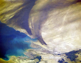
Titre : Oil Well Fires, Kuwait April 1991
Description : (La description de cette image n'existe qu'en anglais)
The Kuwait oil fields of Al Sabiriyah and Al Rawdatayn in the north (above the center of the image) and the Al Burqan in the south (to the right of the center of the image) can be seen burning and producing heavy black smoke plumes in this northeast-looking view. The image was obtained about four weeks after the end of the Gulf War. The Iraqi Government carried out their threat of a “scorched-earth” policy by systematically destroying nearly 80 percent of Kuwait’s oil wells. The thick black smoke, traveling in a southwest direction near the surface, rose in altitude and was picked by the east-flowing sub-tropical jet stream between 16000 feet (4880 meters) to 25000 feet (7625 meters) and blown to the east and northeast out over the Persian Gulf (right portion of the image). At the time of this image, work was just beginning to distinguish the over 750 burning oil well fires. The Tigris/Euphrates Delta is visible in the upper right portion of the image.
|
|

